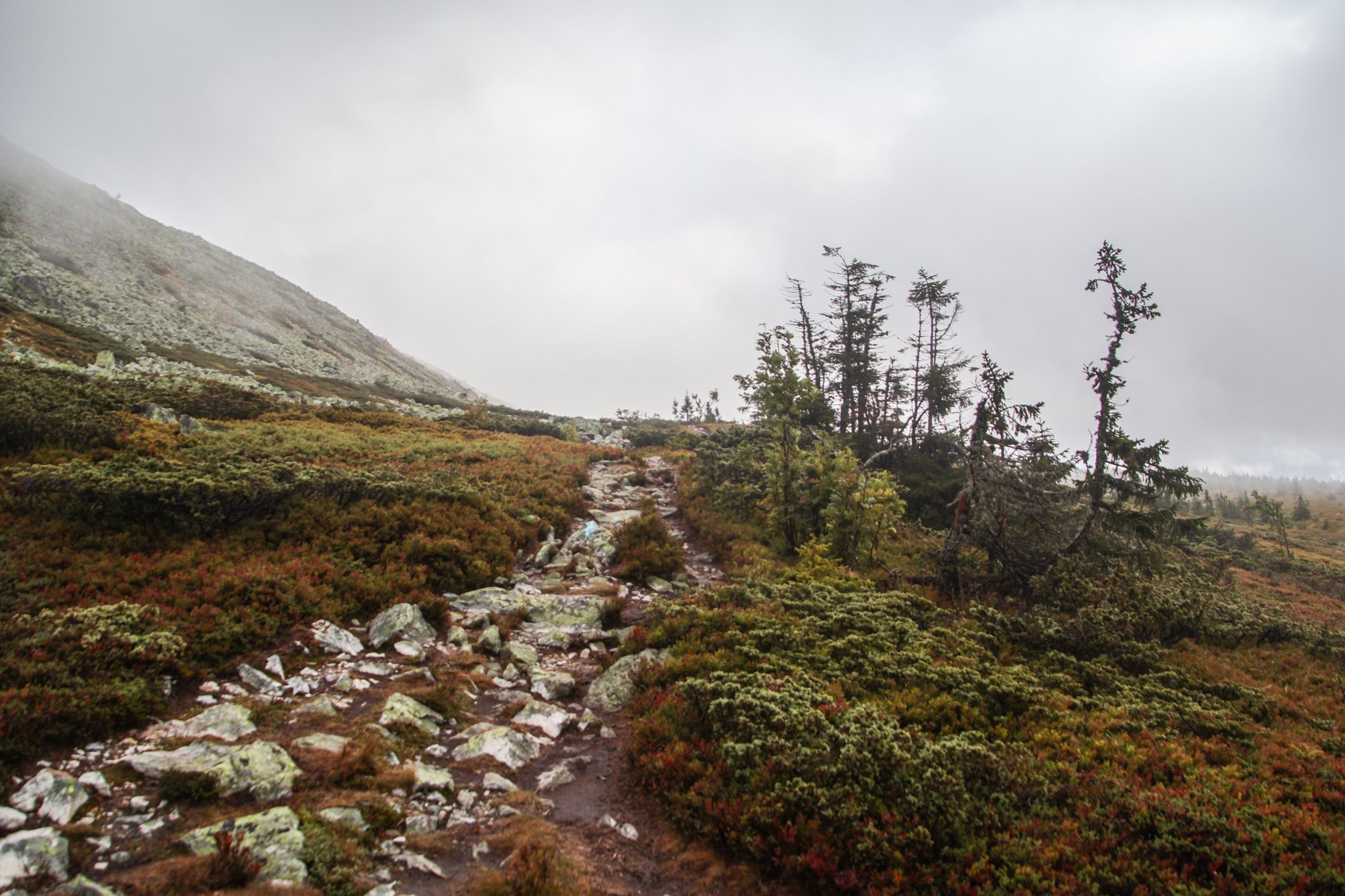
I was excited to see some of Norway’s legendary mountains! Unfortunately, Freyr (the Norse god of good weather) was otherwise occupied during my visit. During our entire stay in Trysil, the landscape was covered in a thick fog and a cold, driving rain. It was perfect weather to cuddle up with a good book in a mountain cabin… but we had other plans.
Bright and early, we set out into the cold, foggy wetness to complete our hike. There were about 5 minutes where the sun managed to poke through the cloud cover, so I’ll show you those photos first. We were not in a particularly scenic part of the trail during that fleeting moment, but even then it was clear that—had we been able to see the landscape around us—it would have been incredible. The sun reveals a stunningly bright color palette on the grass around us.
Maasai Mara—which is often locally referred to as simply, “The Mara”—is the name of a giant nature preserve in southwest Kenya. Its namesake, the Mara River, runs through it, and the word “Maasai” refers to the original tribal inhabitants of this area, who can still be found here today.
Well, as far as I know, the only difference between Maasai Mara and the Serengeti is the border between Kenya and Tanzania. The Mara is the Kenyan side, while the Serengeti is the Tanzanian side. Looking at the map, it might be tempting to think that Maasai Mara is the lesser of the two experiences because it’s so much smaller than the Serengeti, but—while I have not personally experienced both—I’m told this is not the case.
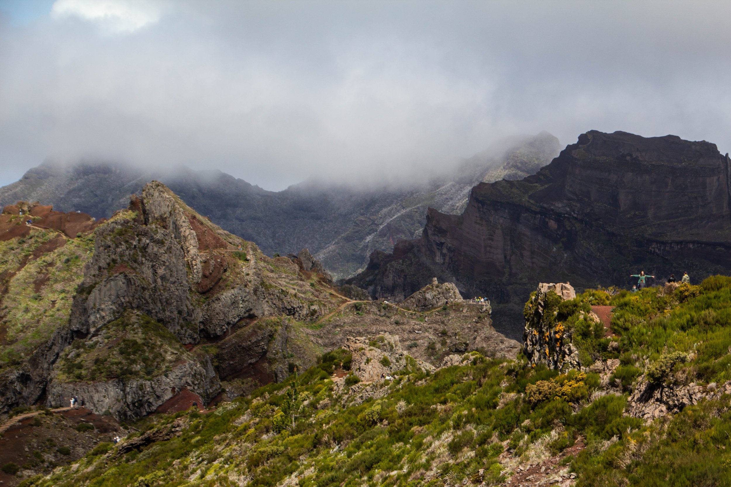
The #1 rated hike in Madeira on AllTrails is the one that from Pico do Areeiro to Pico Ruivo. These are the two highest peaks on Madeira. And in the middle you pass over Madeira’s 3rd highest peak: Pico das Torres. AllTrails ranks this hike as “Hard” and I think most people who do it would agree. But there’s some serious hype around this trek!
“It’s gonna be the coolest hike of your life” my friend said to me confidently after we landed in Madeira.
“…Like, my life specifically?” **Subtext: “You don’t think I’ve done any other cool hikes?” 🥺
“No, dude, like the coolest hike of anyone’s life.”
When you fly into Madeira—assuming you are coming from Europe, which is undoubtedly the most common flight path—you will fly over this jagged, sun-soaked rocky outcropping. Even from the window of the plane, it seems really long. It makes an impression on you immediately that Madeira is going to be a rocky, mountainous place. Which is true. I had sort of forgotten about this little land formation until I looked at the map on the morning of this hike (I wasn’t responsible for planning this portion of the trip 😂)—it turned out, we would be hiking out to the very end of it!
At the time of our visit, Farol da Ponta de São Lourenço was the 2nd most popular hike in Maderia on AllTrails, which I just found out has this cool map embed feature. So here’s the info from AllTrails: it’s categorized as an “intermediate” hike, and you can probably knock it out in a few hours. There are definitely som very steep stretches of trail, but there are also flatter portions where you can catch your breath. And there is also a little oasis in the middle of it in the form of a cafe! I have no idea how these restock that place.
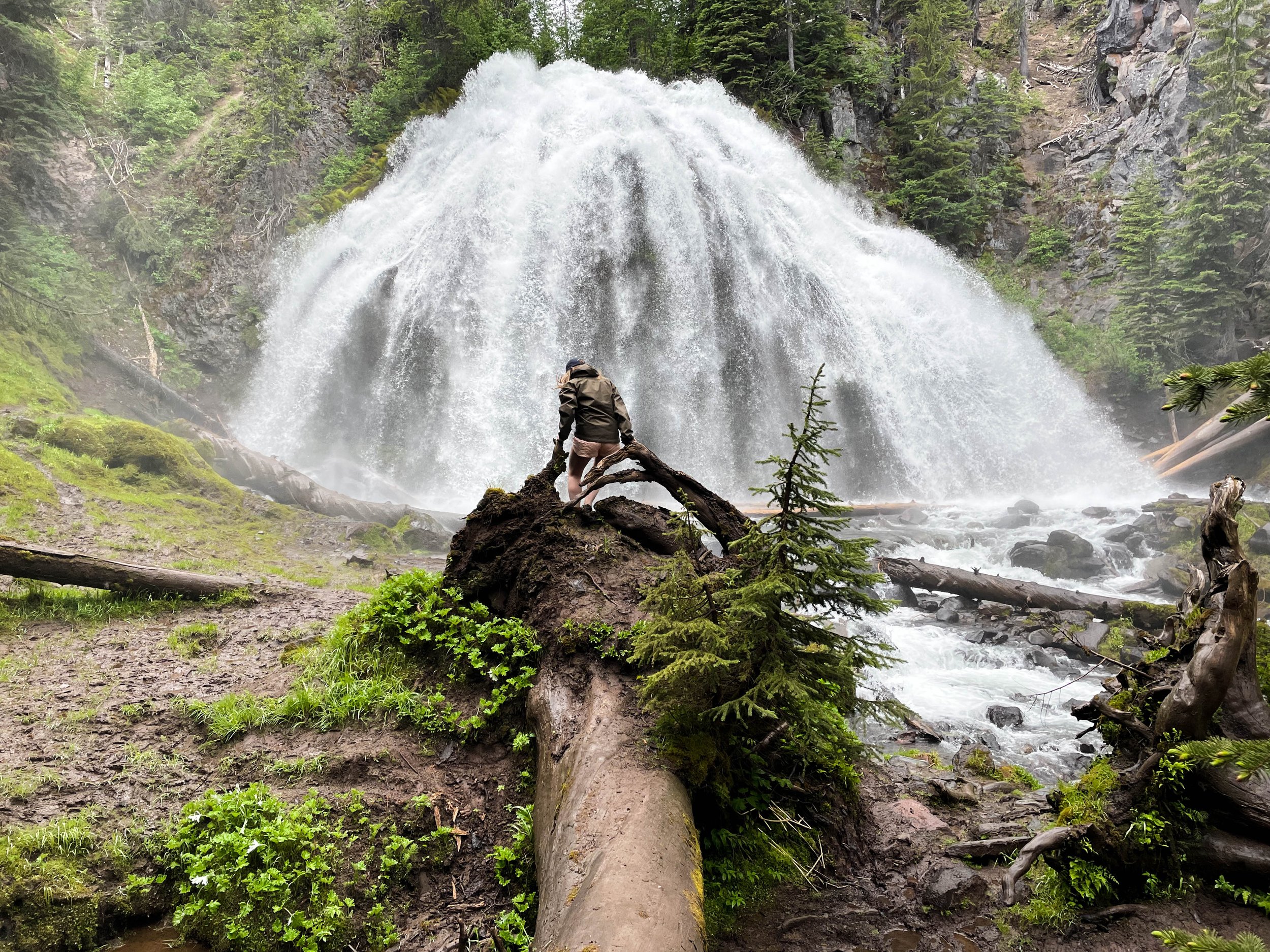
Chush Falls (pronounced “shoosh”) is actually nestled right up against the Sisters Mountains and Broken Top. The drive to get to this trailhead was about an hour from Tam McArthur Rim, all over gravel roads. Oh, and it was absolutely STUNNING. Honestly, even if you don’t do this hike, the drive is still well worth the effort. This was already bringing me closer to these mountains than I had yet been. Looking up at the snowy slopes, I could see every little rock and wisp of cloud clearly and was able to even capture some of this with my camera. And, miraculously, the weather really was clearer over here.
This many mountains is just insane to me. Prior to this trip, this was not what I pictured when I thought of Oregon. This was downright RUGGED! And it was gorgeous. The three mountains in closest proximity to Black Butte, and to one another are the Three Sisters for which this area is named: Middle Sister, North Sister, and South Sister. All three of these mountains are sleeping volcanoes. The North and Middle Sister last erupted ~14,000 years ago and scientists think it’s unlikely that they’ll ever erupt again. However, the South Sister erupted as recently as 2,000 years ago, and could feasibly erupt again. There have been sporadic reports of volcanic rumblings deep within South Sister since 1866, and there have been a couple of minor scares since the late 1980s. Nothing has ever happened, but there is a big pot of magma a few miles beneath the peak of South Sister. Did I mention that South Sister is also the easiest of these mountains to climb? Sign me up for that!! 😵
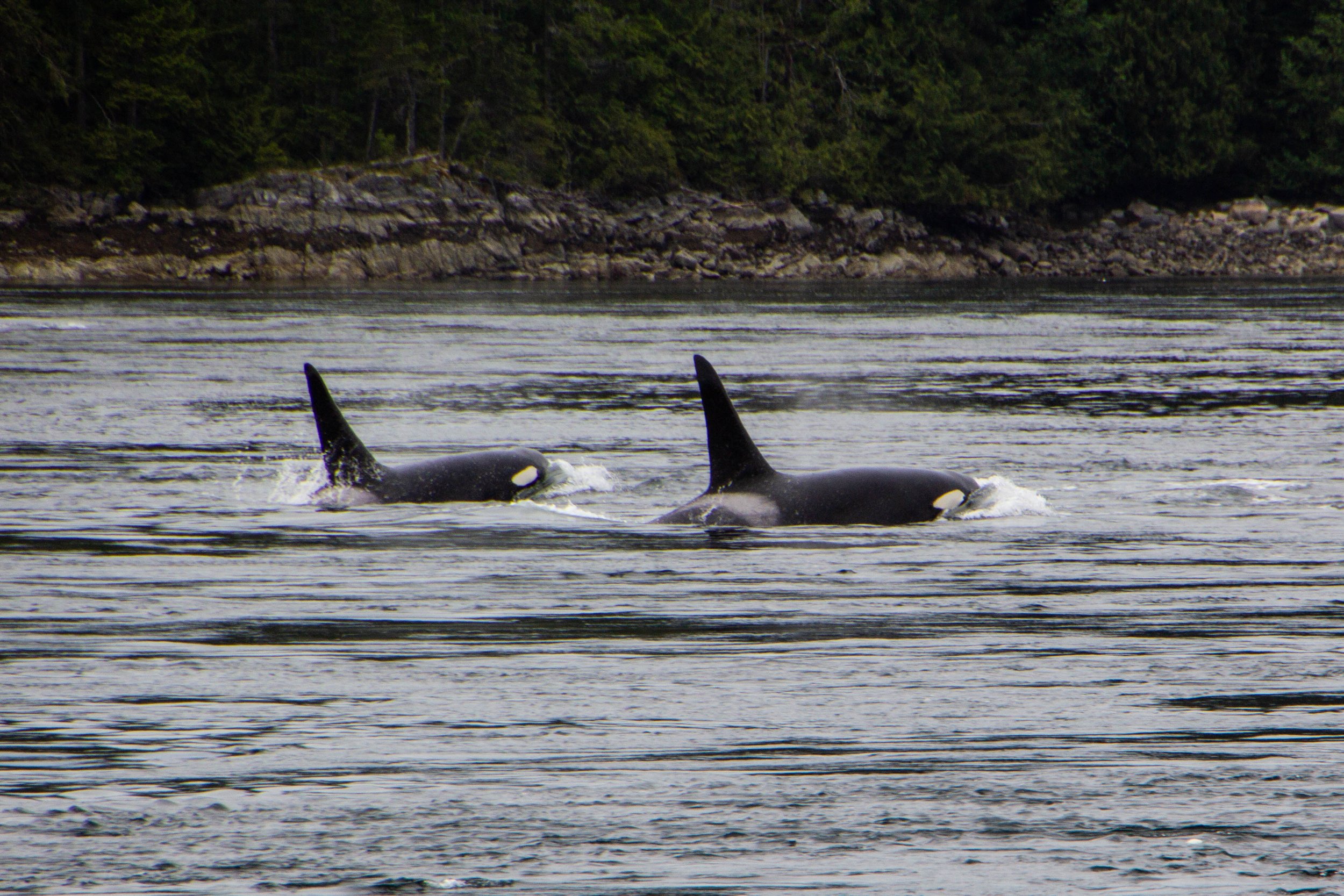
Orcas, or Killer Whales, were something of a feared creature in the olden days. Apparently, back in the 1800s when this part of the world was first being explored by Europeans, their technical/scientific classification was actually “Monster.” Hilarious as this might seem, it does make some sense. Black whales with sharp teeth and shark fins? Yeah, that would have definitely felt somewhat monstrous to me if I was an early sailor of these waters. The conventional wisdom of the day was that, if you fell in the water, you needed to get out ASAP so an Orca wouldn’t eat you. If you hadn’t already guessed this, there is, in fact, no record of an Orca ever eating a human. But this was still a legitimate fear as recently as the 1960s when they actually mounted a machine gun on a coastal bluff known as Chatham Point with the aim of shooting as many Orcas as possible. 🤯 Somehow, for the time when this gun was actively scouring the seas, the Orcas stayed clear of this area and there were no casualties. So Orca/human tensions have never escalated to be anything more than a cold war. And it was not long after this that human sentiments toward Orcas began to change for the better.
Avatar Grove is well-named; it really does feel like something out of Avatar. Or maybe Jurassic Park. It is a tangled, mossy labyrinth of ancient, knotted trees rising out of an infinite carpet of prehistoric-looking ferns. Each tree branch is draped with moss, similar to the way Spanish Moss hangs from every tree in Savannah—but in a green, lush, distinctly Pacific Northwest kind of way. Every little detail of this place was fascinating and photogenic. From the mossy, leafy forest floor, to the canopy high above our heads, every inch felt like its own world.
In the last article, we checked out Sombrio beach, which I think is likely the most easily-accessible stretch of coastline in the Port Renfrew area, and also the place that resembles the classic “beach” (i.e. sand, waves, etc) most closely. However, the majority of Vancouver Island’s coastline is not as easy to access and is NOT your classic sandy beach. This is a rocky, mossy, rugged, chaotic, windswept boundary zone, perpetually pounded with massive waves, riddled with lively tide pools, and entirely unaccommodating to the “beach vacation” experience. It’s also extremely cool.
To give you an idea of exactly how isolated this place is—the one gas station in the area was out of service during our visit, so we had to drive 2.5 hours EACH WAY to get to the next nearest gas station. We had been advised to stock up on groceries in Victoria before coming out here because we’d have to travel similar distances to find a supermarket. Also, Port Renfrew apparently experiences random rolling blackouts from time to time. When the power went out on our last day, we stopped by a local hotel & restaurant that had a generator running to ask how long these blackouts usually lasted—they told us that the last one lasted 2 days. 🤯 Suddenly, the flashlights we found waiting for us in our Airbnb made a ton of sense. That’s part of the deal out here!